 The current temperature on-campus is 67 degrees F. There are light ESE winds at 4mph and about 80% cloud cover with mostly stratus and cumuls clouds. The pressure trend has been very up and down for the past 24 hours as you can see in the graph to the right. There is a low pressure system over Wisconsin, accounting for the cloudy skies. There has also been a cold front that has just passed over us. Now we will experience cooler temperatures than what we have had for the past 2 days. As the system shifts, we will continue to see cooler temperatures, a change in wind direction from ESE to more NE. With this also comes a good chance for precipitation within the next 10 hours or so. Tomorrow will be mostly cloudy with a high in the low 60s and a small chance for rain showers.
 About Me

- Lauren
- I'm a senior Mathematics major with an emphasis in Actuarial Science. I love running, traveling, and the weather!
Thursday, May 12, 2011
Thursday, May 12th
The current temperature on-campus is 67 degrees F. There are light ESE winds at 4mph and about 80% cloud cover with mostly stratus and cumuls clouds. The pressure trend has been very up and down for the past 24 hours as you can see in the graph to the right. There is a low pressure system over Wisconsin, accounting for the cloudy skies. There has also been a cold front that has just passed over us. Now we will experience cooler temperatures than what we have had for the past 2 days. As the system shifts, we will continue to see cooler temperatures, a change in wind direction from ESE to more NE. With this also comes a good chance for precipitation within the next 10 hours or so. Tomorrow will be mostly cloudy with a high in the low 60s and a small chance for rain showers. Tuesday, May 10, 2011
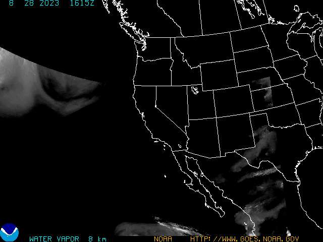
Tuesday, May 10th
The current temperature on-campus is an amazing 75 degrees F. There are 10mph ESE winds and 52% relative humidity. The barometric pressure reading is at about 1002mb, but has been slowly falling since around 11am this morning. A warm front is right over southeastern Wisconsin, so even warmer temperatures are expected. Connected with this front is a low pressure system, which as it nears, is the reason for the falling pressure reading. Right now there is about 10% cloud cover, with mostly altostratus clouds. For tonight, we will see increasing cloud cover and warm temperatures. The low for tonight is 59 degrees. Tomorrow we could reach 80 degrees once the warm front passes over us. There is also a chance for t-storms. Below is the stuve diagram for the station in Minneapolis. It will be interesting to keep watching this into tomorrow and make note of the different index levels. The LI index already indicates that thunder storms are probable and the KI index is in the 50% chance of thunderstorms category.


Monday, May 9, 2011
Monday, May 9th
Storms passed through Eau Claire this morning. There was thunder, lightning, heavy rain, and some areas received hail. Now that the storms have past, we are left with strong ESE winds. We were actually issued a High Winds Warning that is in effect until 4pm. The current conditions are 55 degrees F, dew point 50 degrees F, a pressure reading of about 1006mb, and overcast skies. The pressure reading was falling until about noon, then starting rising, and now is pretty steady. Tonight there will be cloudy skies, and remain in the low 50s.
Thursday, May 5, 2011
Cinco de Mayo!
The day started off with 100% cloud cover but now the clouds have started to break up and we are at about 20% cloud cover, mainly cumulus clouds. The reason for this is because the low has moved over us and is moving eastward. Behind it is a high pressure system and more warm temperatures. Currently on campus the temperature is 54 degrees F with 15mph winds from the west. The pressure reading has been rising since about 1pm this afternoon, which is when the system passed through. It is now at about 1012mb. Tonight calls for clearing skies, a diminishing chance for precipitation, and a low of about 40 degrees F. Tomorrow will be in the 60s with mostly clear skies.
Tuesday, May 3, 2011
Tuesday, May 3rd
My predictions for today were very accurate. We have had mostly clear skies with a few altocumulus and cumulus humilis clouds. Right now it is 55 degrees F with light NE winds from the high pressure system right over central Minnesota. There is still about 10% cloud cover with the same types of clouds I just mentioned. The pressure reading has been steady at around 1030mb. As the high pressure system moves to our south we will have SW winds and slightly warmer temperatures. The steady pressure reading indicates that again tomorrow we will have mostly clear skies. Unfortunately, the jet stream has had a big trough in it causing cold weather in our area and stormy weather along the edge of the trough and cold front. HOPEFULLY this jet stream pattern straightens out and we see a zonal flow. Zonal flow jet stream patterns are associated with relatively mild, dry Pacific air across the country, which is what this spring is definitely lacking across the U.S.
Monday, May 2, 2011
Monday, May 2nd
This weekend we had very unpleasant weather. Saturday we received about a quarter of an inch of rain and moderate west winds. After the cold front moved in Saturday evening, we had S winds and cooler temperatures. Sunday we had gusty SW winds and only reached 41 degrees F. Currently this afternoon we are at 38 degrees F, with a dew point of 27 degrees F. There is a high pressure system to our west giving us NW winds and a rising pressure reading. As the high pressure system moves in, the forecast calls for clearing skies and warmer temperatures. Tomorrow's high will be in the mid to upper 50s.
Friday, April 29, 2011
Friday, April 29th
Finally feels like Spring again. Right now it is 62.4 degrees F on campus, with light SE winds at 3 mph. The pressure reading had been rising since yesterday afternoon, but has started to slowly fall again since around noon. There is a high pressure system right over the Chicago area, giving us our SW winds and clear skies. Currently there is about 10% cloud cover, with just a few low stratus clouds. Because the pressure reading is dropping, we will see an increase in cloud cover this evening. As the cold front, warm front, and occluded fronts move our way, the low pressure system associated with those fronts will cause us to have stronger winds and a chance for precipitation. The forecast for tomorrow is slightly cooler than today with an 80% chance of rain and 20-30mph SE winds.
Thursday, April 28, 2011
Thursday, April 28th
Warmer temperatures are on the way! Although currently it is 44 degrees F with 10mph NNW winds, the barometric pressure reading is rising and has been since about 5am this morning. There is about 80% cloud cover, composed of stratus clouds. Because we do not have NE to S winds, heavy precipitation is not likely, just a chance for light drizzle and overcast skies. The 24 hour surface map shows a warm front moving in tomorrow, which will give us a warmer weekend. Tomorrow we will see a change in wind direction from NW to SE and with that warmer temperatures. The high for tomorrow will be in the low 60s.
Wednesday, April 27, 2011
Wednesday, April 27th
Currently there is 100% cloud cover with stratus and cumulus clouds. There is no precipitation, but this morning there were periods of light drizzle. The current temperature is 43 degrees F with 10mph NW winds. The dew point is at 40 degrees and we're at 90% humidity, so precipitation is likely to form on and off this afternoon. The barometric pressure reading had been falling since yesterday, but since about 7am this morning, it has starting to rise again. A large stationary front has swept across us and is now headed toward the east coast. The surface map shows a trough line forming over us in the next 24 hours representing an extension of isobars from the center of the low. With this will come more precipitation, northwestern winds, and temperatures in the upper 40s.
Friday, April 22, 2011
Friday, April 22nd
Right now in Eau Claire there is light rain, light to moderate southeast winds, and it is 42 degrees F. The barometric pressure has been falling since yesterday and is currently at 1007mb. There is 85% cloud cover, mainly cumulonimbus and cumulus clouds. There is a low pressure system to our southeast and another one to our west, accounting for our south winds. As these lows move north and east, we will have a change in wind direction from SE to NW. Tonight we will continue to see showers and temperatures in the 30s. Tomorrow will be cloudy with a chance for showers, northwest winds, and a high of 54 degrees.
Thursday, April 21, 2011
Thursday, April 21st
The current temperature is 50 degrees F with 7 mph winds from the south. The barometric pressure reading started out at about 1027mb early this morning, then started to fall. It is now falling at a very rapid rate, and currently is at 1022.5mb. We have 100% overcast skies with mixed clouds (hard to tell what they are--stratus & cumulus?). Because of the falling pressure reading and the low pressure system moving toward us, tomorrow we will see an increase in clouds, strong NE winds, and with that, a good chance for precipitation. The high for tomorrow will be similar to today, but the wind will make it feel cooler.
Monday, April 18, 2011
Monday, April 18th

The current temperature is 42.8 degrees F on campus. There are light 2 mph ENE winds and 60% cloud cover, composed mainly of statrus clouds and a few cumulus humilis and cirrus clouds. The barometric pressure reading has been steady for the past 7 or so hours at about 1014.5mb.
To our great misfortune, there is a colorado low forming across the U.S. A Colorado Low that forms in winter and early spring will almost always have precipitation in the form of snow, sleet or freezing rain. Only two elements are needed for wintry weather: cold air and available moisture. What is so alarming to us right now is the fact that temperatures that are just below freezing will retain more moisture than really cold temperatures. The forecast for tomorrow is 39 degrees F, however tomorrow night it will get down to just below freezing, so whatever precipitation we are recieving will turn into snow.
Another factor is the wind. Today we have ENE winds and stratus clouds. Not good. This means there is a strong chance for precipiation in the next 15-20 hours.
Another factor is the wind. Today we have ENE winds and stratus clouds. Not good. This means there is a strong chance for precipiation in the next 15-20 hours.
Friday, April 15, 2011
Friday, April 15th
Today was again cooler than I had predicted, however I was correct in saying it will be windy and cloudy. The current temperature is 45 degrees F but it only feels like 35 degrees F. There are pretty strong winds from the NE, at times gusting over 35 mph. Eau Claire is in a wind advisory until 7pm this evening, indicating winds of 25-35 mph, gusting possibly to 45 mph. The barometric pressure reading has been rapidly falling since around 1am this morning. This is accounting for our overcast skies and strong winds, and also indicating that the low pressure system is approaching. Taking a look at the surface map you can see somewhat of a mid-latitude cyclone forming across the center of the country.  All 4 kinds of fronts are present on the map (I have labeled them), and the center of the low is currently over Kansas, moving NE. Given all of these factors, rain is expected this evening, turning into a wintry mix overnight. Tomorrow will be cold, windy, cloudy, and overall pretty depressing weather for mid-April. The high will be in the low 40's and snow accumulation will (hopefully) be less than one inch.
 All 4 kinds of fronts are present on the map (I have labeled them), and the center of the low is currently over Kansas, moving NE. Given all of these factors, rain is expected this evening, turning into a wintry mix overnight. Tomorrow will be cold, windy, cloudy, and overall pretty depressing weather for mid-April. The high will be in the low 40's and snow accumulation will (hopefully) be less than one inch.
Thursday, April 14, 2011
Thursday, April 14th
I was right in predicting a change to NE winds today, however it turned out to be a little colder than I thought. The current temperature on campus is 47 degrees F but only feels like 41 degrees F. There are 15 mph E winds and overcast skies (stratus clouds). The barometric pressure reading has been slowly falling since about 10am this morning. This accounts for why we experienced a decrease in temperature around that time, and are continuing to see cool temperatures. This falling pressure reading along with east/northeast winds and stratus clouds, indicates there is a low to our south and it is headed our way. This is going to bring more clouds, similar temperatures, and a chance for precipitation. Tomorrow will be cloudy, windy and we will see a high of around 50 degrees F.
Wednesday, April 13, 2011
Wednesday, April 13th
Today turned out to be a pretty nice day. Currently the temperature is 58 degrees F, but we got up to 62 degrees F around 2pm this afternoon. Right now there are very light NW winds and about 50% cloud cover, mainly stratus clouds. The barometric pressure reading has been steady since about 10am at 1017-1018 mb. A cold front swept over us earlier today, leaving us with these slightly cooler temps. In the next 24 hours we will see a slight change in wind direction from NW to NE, along with similar temperatures, partly cloudy skies, and there is a slight chance for precipitation tonight.
Tuesday, April 12, 2011
Tuesday, April 12th
My predictions for today were correct. Currently we are at 64 degrees F with light south winds. We reached a high of 66 degrees today and saw mostly sunny skies with a few cirrus clouds. The next few days we will see cooler temperatures and a chance for precipitation, as the low pressure system moves in from northern Canada. There is a cold front to our west which will also bring cooler temps. The high for tomorrow is in the mid 50s with a chance for a few showers. The wind direction will also switch to NW once the low pressure system moves closer, so it will definitely feel colder than today.
Monday, April 11, 2011
Monday, April 11th
Well, last night did not turn out as predicted for the Eau Claire area. The storms never hit us and we did not recieve any rain, however I did hear some thunder. It was very easy to tell when the cold front passed over us, because the temperature dropped very suddenly and the wind changed direction and became very gusty. Currently this afternoon we are at 54.3 degrees F with moderate W winds. The pressure reading has been increasing since the cold front moved over us, indicating we will see clearing skies and cooler temperatures. Currently there is about 50% cloud cover with low stratus clouds. Tomorrow we will have mostly sunny skies and a high temperature of 66 degrees F.
Sunday, April 10, 2011
Sunday, April 10th
 Storms are on the way! To the left there is a picture of the current stuve diagram from the station in Minneapolis. The indices on the right-hand side indicate the possibility of thunderstorms. The LI index is -3.2 meaning thunderstorms are probable. The KI index is 29 which is in the 50% chance of thunderstorms category. Taking a look at some of the other indices... the EHI (Energy-Helicity Index) is at 2.0 which means Mesocyclone-induced tornadoes are possible (F0-F1 damage).The Sweat index is at 569 which falls in the category of strong risk of severe, few thunderstorms, isolated tornadoes.
Currently, the temperature is 63.9 degrees F with 13 mph SE winds. The dew point is 57.9 degrees F and there is 81% relative humidity. The barometric pressure reading is at 996.5 mb and has been falling for the past 24 hours. The surface map shows a low pressure system right over southern Minnesota. At this spot there is a cold front coming in from the west, and it is mixing with a warm front coming up from the south. With everything that I've just mentioned, thunderstorms are very likely to develop in the next few hours. It will be interesting to keep watching the different maps as the system approaches. After the cold front moves over us, we will have NW winds and colder temperatures. Tomorrow's high is 58 degrees F and winds could occasionally gust over 40 mph.
Thursday, April 7, 2011
Thursday, April 7th
The current weather is 62 degrees F with light SE winds and about 30% cloud cover, with cirrus clouds. The barometric pressure trend over the past 24 hours has been increasing, then high and steady this afternoon, and now it is beginning to fall. This explains why earlier today we had clear skies and now clouds are just starting to move in. There is some weather to the south of us on the north side of the stationary front, but all is calm in Wisconsin. The forecast for tomorrow is a few more clouds, more SE winds, and more warm temperatures (in the 60's).

On the water vapor map I have indciated where the jet stream is and also where a dry line is located.

On the water vapor map I have indciated where the jet stream is and also where a dry line is located.
Wednesday, April 6, 2011
Wednesday, April 6th
Today has been a beautiful spring day. We reached 56 degrees F and are currently at 54 degrees F at 7pm. There have been light winds today that started as NE and are now N winds. Currently there is about 30% cloud cover with high cirrus clouds and low stratus clouds. The jet stream has a slight ridge over the center of the country, but is mainly flat. It shows that the strongest upper level winds are over the great lakes and the NE part of the country. The barometric pressure reading has been increasing over the past 24 hours so overnight we will continue to see clearing skies and cool temps. Tomorrow will be warm again with partly cloudy skies as a low pressure system forms south of us.
Monday, April 4, 2011
Monday, April 4th
This weekend we finally had some nice, spring-like weather. We reached 48 degrees on Saturday with sunny skies, and yesterday we hit 44 degrees with overcast skies. This morning started out very gloomy and did not feel like spring. Now the clouds have broken up slightly. Currently there is about 80% cloud cover, with cumulus congestus and cumulonimubus clouds. There is a light rain and WNW winds at about 25 mph. The temperature is 42 degrees F, but with the wind chill it only feels like 28 degrees F. Unfortunately I've had to walk over the bridge a couple times today, however when I did, I noticed that the river has definitely risen. It is just short of reaching the bike trail. Tonight we will see decreasing clouds as the low pressure system moves east. Tomorrow will be noticabley warmer but with more moderate winds and increasing clouds in the evening due to another low pressure system.
Friday, April 1, 2011
Friday, April 1st
We received snow showers over night and this morning. About an inch had accumulated on my car by this morning, but it looks as though throughout the day it has melted. Late morning and into the afternoon, the snow turned into a light rain drizzle. Currently on-campus the temperature is 32 degrees F with light east winds and overcast skies. The clouds appear to be stratus and nimbostratus clouds. The pressure reading is steady, so I predict the weather will stay the same for the rest of the day. As the low pressure system moves away from us tomorrow, we will see partly cloudy skies and temperatures again in the mid-40s.
The 48-hour surface map from intellicast.com shows a mid-latitude cyclone forming on Sunday which will loop up over WI and MN and over to MT. This means another chance for precipitation on Sunday.
 |
The 48-hour surface map from intellicast.com shows a mid-latitude cyclone forming on Sunday which will loop up over WI and MN and over to MT. This means another chance for precipitation on Sunday.
Thursday, March 31, 2011
Thursday, March 31st
My prediction for today was mostly accurate. We now have light winds coming from the SE direction. This changed happened late morning, around 11am. We started out the day with overcast skies, but now the clouds have broken up and we have about 50% cloud cover, with cumulus humilis and altocirrus clouds. Currently our temperature is 43 degrees F, which is a nice break from the really cold temps. Our barometric pressure reading is falling rapidly which indicates more clouds are moving in. Also, because the wind direction has switched from NE to S/SE, and the current cloud pattern, there is a good chance for precipitation in the next 15 or so hours. Because of this unsual jet stream pattern for this time of year, we will continue to see cooler than normal temperatures throughout the week and weekend. Hopefully April will start to feel more "Spring-like" soon!
Wednesday, March 30, 2011
Wednesday, March 30th
Today is appearing to turn out as predicted. The current temperature is 33 degrees F with no wind and brilliantly sunny skies. The surface map shows a stationary front to the west of us, along with a large U-shaped cold front in the south. This matches up with the snow/rain mix in the Dakotas and Nebraska, and the precipitation/inclimate weather the southeastern states are experiencing. Our barometric pressure reading is falling slowly, so as the high pressure system moves to our southeast we will see an increase in clouds, as well as a change in wind direction. Tomorrow we will have SE winds, mostly cloudy skies, and reach the upper 40s.
The big weather news right now is the possibility of a big snow storm out east on Thursday night and Friday. They are concerned because the cold front in the south (from the continental polar airmass) will mix with a warm front along the east coast (from the maritime tropical airmass) and a large low pressure system will form. Because of this, strong winds and wet heavy snow are very possible.
 |
Tuesday, March 29, 2011
Tuesday, March 29th
Today was a little warmer than yesterday, as predicted. We reached 40 degrees F and had light north winds. There were a few small cumulus and stratus clouds, only about 30% cover. Right now it is 25 degrees F with light north winds. Tomorrow will continue on this same pattern, with highs in the low 40s and light north winds. The pressure reading is slowly rising, indicating we will have clear skies tomorrow.
Monday, March 28, 2011
Monday, March 28th
I was right in prediciting that today would be similar to yesterday. The current temperature is 32 degrees F. The high pressure system is right over Wisconsin, accounting for our clear skies. There are very light northeast winds so it feels like 32 degrees F. The barometric pressure reading is steady at 30.32" so the rest of today should remain clear and cold. Taking a look at the surface map, the high pressure system will shift further north tomorrow, so we will see a few more clouds, along with slightly warmer temperatures and east winds.
Sunday, March 27, 2011
Sunday, March 27th
All I can say is, at least the sun is shinning. Yesterday I got back from Georgia, where I was for the past week, and was disappointed to see more snow. There is a big trough in the jet stream dipping down over the southeast part of the country. This is causing severe weather there and I am very glad I left before it all began. The current temperature here in Eau Claire is 30 degrees F with light northeast winds. There is about 10% cloud cover, mainly small cumulus humilis clouds in the northern part of the sky. Tomorrow will be very similiar to today, as the high pressure system stays right over Wisconsin and leaves us with mostly clear skies and temperatures in the low 30s.
Saturday, March 19, 2011
Saturday, March 19th
Nice day to start off spring break! My predictions were right on. Currently it is 43 degrees F with warm 8 mph SE winds and clear skies. The sun is shinning and the temperature continues to rise every hour. Intellicast.com says we will reach 51 degrees F this this afternoon and I believe that will be accurate. Based on the water vapor map and the fact that the pressure reading is falling, clouds will start to move in later today and we will have warmer temperatures. Unfortunatley, late tonight there will be a change in this nice weather. There is a good chance for rain showers tonight. This will continue throughout most of tomorrow, because there will be a cold front colliding with a warm front right over Wisconsin. This will give us rain and maybe even a little thunder. Temperatures will be similar to today, but the winds will increase so it will not feel as pleasant.
Friday, March 18, 2011
Friday, March 18th
A cold front did move in as predicted, and left us with cooler temperatures. Right now it is 35 degrees F but feels like 28 degrees F. The barometric pressure reading is at 30.26" and slowly rising so the skies are clearing. Looking out the window at work, I see altocumulus clouds and would guess that the cloud cover is about 30%. There are light to moderate at times NW winds from the high pressure system over western Minnesota. The surface weather map shows another cold front coming in from our northest, so temperatures will drop tonight. Skies will continue to clear as a high pressure system forms right over Wisconsin. Tomorrow will be sunny and warmer with south winds.
Thursday, March 17, 2011
Thursday, March 17th
My predictions were very accurate for today. There is a low pressure system to our north giving us moderate WNW winds. Temperatures today have been slightly warmer than yesterday with a current temperature of 51 degrees F (on campus). Earlier today there were overcast skies and at times it was misting a little. Now the clouds have started to break up and there is about 60% cloud cover - mainly stratus clouds. The air pressure is slowly rising, accounting for the clearing of the clouds. There is weather to our north because two fronts are colliding, therefore the two different airmasses are mixing and producing inclement weather. Tonight, temperatures will fall and the winds will start to come in more from the north. Tomorrow a cold front will move in so it will be cooler with a high around 40 degrees F and moderate N winds.
 |
| Frost on a shamrock! Happy St. Patricks Day! |
Wednesday, March 16, 2011
Wednesday, March 16th
About an hour after I blogged yesterday it started raining, so unfortunately I was wrong. However, my prediction for today was correct. The day started out with a dense fog advisory but I was not up early enough to see what kind it was. I would guess it was advection fog. The high today was 50 degrees F with partly cloudy skies. I went on a walk around 6pm and to the west was a mackeral sky with altocumulus clouds. To the east there were stratus clouds. A warm front did move in and we had light south winds. As a low pressure system forms to our north, we will have a change in wind direction from south to west/northwest. Also, the barometric pressure reading will continue to fall and tomorrow we will have much more cloud cover. Tomorrow should be as warm as today with a 30% chance for precipitation.
Tuesday, March 15, 2011
Tuesday, March 15th
Today was warmer and cloudier as predictied. The current temperature is 45 degrees F which is our high for the day. We have seen increasing clouds, first cirrostratus now a mix of cirrostratus and some small cumulus. I would say the current cloud cover is about 60%. There are slight to moderate at times WSW winds. The dew point is 26 degrees F and the barometric pressure is steady at about 30". Because of these two facts and how I don't really see any nimbus clouds, I do not think we will have any precipitation this evening, although sources indicate otherwise. Tomorrow should be slightly warmer due to a small warm front coming in from the south and south winds, with about the same amount of cloud cover.
Monday, March 14, 2011
Monday, March 14th
My prediction for today was correct. This morning started out chilly and brilliantly sunny, but it has definitely warmed up. The current temperature is 36 degrees F with light SSE winds and about 30% cloud cover, mainly stratus clouds. The SSE winds are from the high pressure system over Michigan rotating the air in a clockwise direction. The current barometric pressure reading is 30.31" and is slowly falling, indicating a few more clouds will move in. Tomorrow we will continue to see increasing temperatures and cloud cover. There is a chance for precipitation tomorrow evening.
 |
| Current water vapor image - notice the hurricane-like shape over the middle of the country. This is a midlatitude cyclone and corresponds with the current radar image that shows a line of storms right along the edge of the dark area. |
Sunday, March 13, 2011
Sunday, March 13th
My prediction for Saturday was correct. The morning was not pleasant weather. It was windy and cold. I drove to Hudson yesterday morning, and the more east I got, the stronger winds/more precipitation I encountered. Today turned out to be a nice day. It was cold and cloudy early this morning, but skies cleared to about 20% cloud cover (stratus clouds) and we reached a high temperature of 31 degrees F. The clearing skies were due to the center of the high pressure system moving over us. It stayed light out for longer too, thanks to daylight savings. It will probably be harder to get out of bed in the morning though :( Tomorrow should be slightly warmer, with mostly clear skies.
Friday, March 11, 2011
Friday, March 11th
I had predicted SW winds for today, however they are more SE winds. The current temperature is 34 degrees F, but we should get up to 40 later this afternoon as the small warm front passes over us. There is about 50% cloud cover, with mainly stratus clouds. Tonight there is a good chance for precipitation. As the low pressure system gets closer, we will see stronger winds. The wind direction will change from SE to SW and eventually to W as the system moves in. The low for tonight is 26 degrees F and the barometric pressure reading is falling rapidly indicating clouds and precipitation on the way. The foracested surface map shows isobars close together over WI meaning tomorrow will be windy. It will also be colder because a cold front is moving in.
Thursday, March 10, 2011
Thursday, March 10th
My prediction for today was pretty accurate. We had clear skies this morning, and now there is about 30% cloud cover, mostly cirrus clouds. The current temperature is 37 degrees F with 12 mph NW winds. There isn't much weather on the surface map, as the storm system has past and is on the east coast. Taking a look at the 24 surface map forcast, it looks as though a small warm front will move in, followed with a low pressure system to our west. The low pressure system should give us SW winds and the warm front will give us warmer temperatures, possibly reaching into the low 40s. Tomorrow night there is a chance for precipitation.
Wednesday, March 9, 2011
Wednesday, March 9th
It is hard to state the accuracy of my prediction for snowfall today, because whatever we got seems to have already melted. It snowed all morning and into the afternoon, so if I had to guess I would say 2 or 3 inches. The current temperature is 36 degrees F, dew point is 17 degrees F, there are overcast skies, and light north winds. Tomorrow there will be more north winds from the high pressure system to our north. The barometric pressure reading is rising slowly according to the weather station on campus, so for tomorrow I predict it to be a little less cloudly than today, but with similar temperatures.
Tuesday, March 8, 2011
Tuesday, March 8th
I was correct in predicting cloudy skies and warmer temperatures, as the high today was 38 degrees F. Currently it is still 32 degrees F with light snow and east/northeast winds of about 11 mph. As the low pressure system continues to move northeast, the winds will switch to north/northeast. This will bring slightly cooler temperatures, more clouds, and more precipitation tomorrow. The national weather service is calling for 2-5 inches by tomorrow night. This storm's intensity has definitely lessened from the original prediction made last week. There was predicited to be a wider trough in the jetstream containing a larger pocket of cold air.
 |
| Current jetstream taken from http://www.intellicast.com/National/Wind/JetStream.aspx |
Monday, March 7, 2011
Monday, March 7th
I was not correct in my wind prediction for yesterday, as we had SE winds instead of NE winds. I was correct however in prediciting similar temperatures and no snow. This morning we had a light snow shower which gave us just a trace of snow. The current temperature is 32 degrees F with overcast skies, and light south winds from the high pressure system to the SE of us. After taking a look at the forecasted surface map, tomorrow the center of a low pressure system will be right over us. The rising air in a low pressure center favors the development of clouds and precipitation, so cloudy weather and warmer temperatures are very likely tomorrow. Weather.com has indicated our area is in a Winter Storm watch beginning tomorrow night, so that is when the snow is predicted to start.
This is the water vapor map of the western U.S. There is an obvious "U" shaped line stretching across the Baja California Peninsula up through Colorado/Kansas. I believe this is called an upper-level trough.
Saturday, March 5, 2011
Saturday, March 5th
Current conditions are sunny skies with about 40 % cloud cover, mainly cirrus and cumulus clouds. It is 28 degrees F with 10 mph north/northeast winds. The rest of the day should remain the same, with a low of 9 degrees F tonight. Tomorrow I predict we will see similar temperatures and more north/northeast winds from the high pressure system to our north. There is a small chance for snow showers tomorrow night.
Thursday, March 3, 2011
Thursday, March 3rd
It didn't feel as warm as I had thought it would today, however there were a few snow showers this morning as I predicted yesterday. Currently it is still 30 degrees F at 7pm, which is impressive. There are light NE winds which will continue throughout the night. Due to the cloud cover it is going to stay relatively warm tonight, leading to warmer temperatures tomorrow. There is a warm front and a low pressure system to our south, and as they move east, we will have slightly warmer temperatures and east winds. The high will reach the mid 30s and there is another chance for precipitation.
Wednesday, March 2, 2011
Wednesday, March 2nd
I was correct in my prediction yesterday for a cold front moving across WI. It was especially noticable last night when the winds picked up and it got a lot colder. Currently it is 14 degrees F with a wind chill of 6 degrees F. Today there were clear skies due to the high pressure system being centered right over us. Now as the high pressure system has moved east, there is about 70% cloud cover with stratus and cumulus clouds, however it is hard to tell exactly because it is almost dark out. The winds have died down and are very light winds from the north. As the high pressure system continues to move east, it will give us south winds and warmer temperatures tomorrow. With the combination of a change in wind direction and a falling barometric pressure reading (according to http://metstation.uwec.edu/Current.htm), this indicates a chance for precipitation.
Tuesday, March 1, 2011
Tuesday, March 1st
As predicted yesterday, the high pressure system moved south and left us with warmer weather. The current temperature is 38 degrees F with about 45% cloud cover, mainly cirrus clouds. There are now two high pressure systems affecting the air movement in our area, one to our south and one to the southeast. This is accounting for our WSW winds. As a cold front passes over WI this evening and a high pressure system moves in from the north, we will see colder temperatures and a change in wind direction. The high for tomorrow will only be in the upper teens with light north/northwest winds.
 |
| Surface map from http://www.weather.com/maps/ at 2:22pm |
Monday, February 28, 2011
Monday, Feb. 28th
Over the weekend we saw very cold temperatures on Saturday, followed by warmer temps on Sunday. The change in wind direction from north winds on Saturday to south winds on Sunday, helped aid in the warm up. Currently on campus, the temperature is 14 degrees F with light WSW winds. There is a high pressure system to the west of us accounting for the westerly winds and clearing skies. Because the current dew point is 5 degrees F and there are brilliantly sunny skies, precipiation is very unlikely. As the high pressure system moves south, we will have south/southwest winds tomorrow and warmer temperatures. The high for tomorrow is 36 degrees F, with mostly cloudy skies.
Friday, February 25, 2011
Friday, Feb. 25th
Currently on campus it is 13.5 degrees F but feels like 3.7 degrees F. Due to the large trough in the jet stream and the high pressure system roating the air clockwise, we have very light west winds and the sun is shining brightly (unlike this morning), so it doesn't feel too cold. The current cloud cover is about 10% with some low stratus clouds to the west. There is a slight chance of flurries this evening, as the dew point is at 1 degree F. Tomorrow's high is 14 degrees F and there is an increased chance of snow showers, especially in the morning.
Thursday, February 24, 2011
Thursday, Feb. 24th
Currently the temperature is a pleasant 30 degrees F with light north winds at 6 mph. There was about 30% cloud cover before class, but now there is about 90% cloud cover with mostly stratus clouds. For the rest of today and into tonight we will continue to see cloudy skies, with temperatures dipping down to 11 degrees F. As mentioned in yesterday's blog, tomorrow will be cooler with a high of only 16 degrees F. This is due to the cold front that crossed over WI and the north winds we are getting from the storms to the south of us.
Wednesday, February 23, 2011
Wednesday, Feb. 23rd

Tuesday, February 22, 2011
Tuesday, Feb. 22nd
The current temperature is 25 degrees F with south winds at 9 mph. There are partly cloudy skies with a mix of stratocumulus and cumulus clouds. The dew point is 14 degrees F, so unlike yesterday, there has been no precepitation. As the high pressure system moves east, it will continue to move the air in a clockwise direction, giving us more south/southeast winds. Tomorrow we will also see more clouds and warmer temperatures, with a high of 35 degrees F.
 |
-->This is a picture I took of an icicle that has formed on the corner of my house... I'm scared to walk underneath of it!
Monday, February 21, 2011
Monday, Feb. 21st
According to the weather station on top of Phillips, it currently feels like 9 degrees F. There are 13 mph winds from the ENE. There is 100% cloud cover with light snow. The barometric pressure reading is rising slowly so the snow should be ending soon. The forecast calls for more clouds and simliar temperatures. There is a low pressure system right over Iowa causing the air to move in a counter-clockwise direction, accouting for our east northeast winds. Tonight we will see additional scattererd snow showers, finally ending early tomorrow morning. Hopefully the city will get the side streets and sidewalks plowed by tomorrow so we don't have to trudge through snow mountains again.
Sunday, February 20, 2011
Sunday, Feb. 20th
Current conditions are 26 degrees F with a wind chill of 11 degrees F. There was heavy snow this afternoon, but now it has tapered off to a light snow. There is 100% cloud cover and 24mph east winds gusting to 30-40mph. Tonight's low is 18 degrees F and there will be strong winds along with an additional 4-6 inches of snow. The high for tomorrow is 20 degrees F and a few more inches of snow is expected. More moderate to strong winds from the east will cause blowing and drifting snow. Praying for a snow day!
 |
| View from RCU skycam at 5:30pm |
Friday, February 18, 2011
Friday, Feb. 18th
It's nice to see the sun again! Yesterday was very gloomy, but today there are brilliantly sunny skies. The current temperature is 28 degrees F but it feels like 16 degrees F. If you can avoid walking over the bridge I would highly recommended it because it is very windy. There are 20-30 mph W wind gusts, making it feel a lot colder than it is. The current barometric pressure reading is 30.1 in Hg and is rising, accounting for the clear skies. Tonight will get down to 10 degrees F with a few passing clouds and moderate NW winds. Tomorrow's high is 31 degrees F and starting tomorrow evening we are in a Winter Storm Watch.
Thursday, February 17, 2011
Thursday, Feb. 17th
Currently it is 36 degrees F and feels like 26 degrees F. Earlier today we reached 45 degrees F and had very dense fog, specifically advection fog. This type of fog is formed when a warm moist air mass blows over a cold surface (usually snow or ice). The winds have changed from south to west northwest and are gusting up to 28 mph. This change in wind direction is due to the low pressure system over northern MN. With the low pressure system the air is moving counter-clockwise, giving us the westerly winds. Along with this system will be cooler temperatures, as the high for tomorrow is 33 degrees F.
Wednesday, February 16, 2011
Wednesday, Feb. 16th
Current conditions are 47 degrees F under sunny skies with high cirrus clouds. There is a light 4 mph south wind and it feels like 50 degrees F. Tonight more clouds will move in and a chance of precepitation is possible. The high pressure system is moving southeast so we will see the back side of it. This means we will have more south winds and warmer temperatures. Tomorrow there is a high of 52 degrees F and mostly cloudy skies.

Comparing the current temperatures map to the current surface map shows how the two high presssure systems over the U.S. are leaving most of the country with warm temperatures and south winds.
Comparing the current temperatures map to the current surface map shows how the two high presssure systems over the U.S. are leaving most of the country with warm temperatures and south winds.
Tuesday, February 15, 2011
Tuesday, Feb. 15th
Earlier this afternoon there were altostratus clouds and it was hazy. Now we have fair skies and a temperature of 39 degrees F. There are light south winds, caused by the high pressure system over the northeast pushing the air clockwise. The jet stream has leveled off so most of the U.S. is experiencing little or no precepitation and not as cold of temperatures. As the pressure system moves it will give us warmer temps as well as a chance for precepitation. Tomorrow there is a high of 43 degrees F and mostly cloudy skies.
Monday, February 14, 2011
Monday, Feb. 14th
This week is definitely going to diminish our snow banks. Right now it is 37 degrees F with light SW winds. It is partly cloudy with a wind chill of 32 degrees. Tonight it will get down to 24 degrees F with 10 to 15 mph S winds. Tomorrow should be very similar to today with mostly cloudy skies and a high of 39 degrees F. Happy Valentines day!
Sunday, February 13, 2011
Sunday, Feb. 13th
Feels like Spring! The current temperature is 39 degrees F and it's dark out! We reached 45 degrees today and there were moderate W winds with partly cloudy skies. Tomorrow there is a high of 34 degrees F with stronger west winds. This water vapor map shows dark areas over MN which could head our way, meaning there is chance for precepitation.

Friday, February 11, 2011
Friday, Feb. 11th

This current surface map from intellicast.com shows how there is a warm front making a backwards "J" around MN and WI. In front of a warm front there is cold air and behind it there is warm air, so this would explain why it is still cold outside. The current temperature is 11 degrees F with very light SW winds. However, starting around 4pm, temperatures will start to increase rapidly as more clouds form and the warm front approaches. The high for tomorrow is 33 degrees F with a slight chance of percepitation due to the falling air pressure. Cheers to a warm weekend!
Thursday, February 10, 2011
Thursday, Feb. 10th
According to the weather station on top of Phillips, the current temperature is 13 degrees F with a wind chill of 6 degrees F. There are sunny skies and very light W winds. The jet stream is shifting upward, and a small warm front is headed our way... which means warmer temperatures are in the forecast. The barometric pressure is continuing to fall, so there will be increasing clouds over night and into tomorrow.
Wednesday, February 9, 2011
Wednesday, Feb. 9th
Today is yet another very cold day. The current temperature feels like -6.3 degrees F (according to the temperature reading on top of Phillips). There are 15 mph W winds and completely sunny skies. The good news is a warm up is on the way. Tomorrow's forecast calls for light SW winds, increasing clouds, along with warmer temperatures. Tomorrow's high is 13 degrees F.
Tuesday, February 8, 2011
Tuesday, Feb. 8th
Very cold today. The current temperature is 7 degrees F, and feels like -8 degrees F. The sinking air from the high pressure system has given us mostly clear skies. The barometric pressure reading is falling rapidly, indicating clouds will form and allow for warmer weather. Tonight could get down to -20 degrees F with the wind chill. Tomorrow's high is 9 degrees F with moderate west winds.

(image from accuweather.com showing the bitterly cold weather much of the country is experiencing)
Monday, February 7, 2011
Monday, Feb. 7th
There is a cold front currently stretching from Kansas up to Michigan (shown in the map below) which has left us with colder temperatures. This has also caused a change in wind direction from south to northwest. It is 17 degrees F now with 100% cloud cover and NNW winds of about 12 mph. Tonight will be very chilly, with wind chills approaching -25 degrees F. Tomorrow will remain cold with a high of 5 degrees F and partly cloudy skies.
Saturday, February 5, 2011
Saturday, Feb. 5th
100% cloud cover and light south winds has brought warm temperatures for WI. Currently in Green Bay it is 28 degrees F and could reach 33 degrees F - above freezing for the first time all year! There is a chance for snow tomorrow, along with more cloudy skies and warm temperatures. The forcast for Eau Claire is similar to Green Bay's forcast.
Friday, February 4, 2011
Friday, Feb. 4th
The current temperature is 28 degrees F, which is the warmest it has been in awhile. There is a light SW wind of about 10 mph and mostly sunny skies. More clouds will move in tonight, keeping the temperature in the 20s. Tomorrow will be a little warmer than today with mostly cloudy skies and a high of 31 degrees F. Tomorrow night and through Sunday there is a chance for snow showers. Overall this weekend should be a nice break from the bitter cold weather we've had all week. Plus, it's super bowl weekend - GO PACK GO!

Thursday, February 3, 2011
Thursday, Feb. 3rd
This morning started off very chilly but as the day progressed it definitely warmed up. We were able to make it up to 24 degrees F, thanks to the southwestern winds. Currently it is 17 degrees F, with 14 mph wind gusts at times (I just went on a run and the wind definitely made it challenging). Tonight the temperature will drop down to around 10 degrees F with partly cloudly skies. Tomorrow there is a chance for some snow flurries with stronger SSW winds. The high for tomorrow is 30 degrees F - heat wave!
Wednesday, February 2, 2011
Wednesday, Feb. 2nd
Although today has been sunny and very pretty out, looks can be so deceiving. The current tempeture is 8 degrees F, but it feels like it is -5 degrees F. There a NW wind of about 10 mph. Tonight will get down to -3 degrees F, with wind chills in the negative teens. Tomorrow should be warmer as clouds move in and the wind direction changes to SW.
Tuesday, February 1, 2011
Snowfall Totals so far...
 This is a chart from AccuWeather.com that shows total snowfall this winter season compared to to winter season last year. Notice how Minneapolis's snowfall total is already twice as much as last year, which is probably similar for the Eau Claire area as well.
 Tuesday, Feb. 1st
This afternoon there are sparse altocumulus clouds, with moderate winds from the NNE. The sky is hazy with patches of sun. Current temperature is 18 degrees F. The northeast winds will bring cold temperatures tonight with wind chills dropping to -15 degrees F. Tomorrow will be a little cooler with brilliantly sunny skies. More NNE winds, slightly stronger than today.
Monday, January 31, 2011
Monday, Jan. 31st
The steady snowfall that we've had throughout the morning should begin to taper off as the afternoon progresses. Periods of light snow will continue throughout the evening. Current temperature is 18 degrees F and will fall to around 10 degrees F overnight. Tomorrow will be similar temperatures as today, with AM snow flurries followed by cloudy skies for the rest of the day.

Subscribe to:
Posts (Atom)