About Me

- Lauren
- I'm a senior Mathematics major with an emphasis in Actuarial Science. I love running, traveling, and the weather!
Wednesday, March 9, 2011
Wednesday, March 9th
It is hard to state the accuracy of my prediction for snowfall today, because whatever we got seems to have already melted. It snowed all morning and into the afternoon, so if I had to guess I would say 2 or 3 inches. The current temperature is 36 degrees F, dew point is 17 degrees F, there are overcast skies, and light north winds. Tomorrow there will be more north winds from the high pressure system to our north. The barometric pressure reading is rising slowly according to the weather station on campus, so for tomorrow I predict it to be a little less cloudly than today, but with similar temperatures.
Tuesday, March 8, 2011
Tuesday, March 8th
I was correct in predicting cloudy skies and warmer temperatures, as the high today was 38 degrees F. Currently it is still 32 degrees F with light snow and east/northeast winds of about 11 mph. As the low pressure system continues to move northeast, the winds will switch to north/northeast. This will bring slightly cooler temperatures, more clouds, and more precipitation tomorrow. The national weather service is calling for 2-5 inches by tomorrow night. This storm's intensity has definitely lessened from the original prediction made last week. There was predicited to be a wider trough in the jetstream containing a larger pocket of cold air.
 |
| Current jetstream taken from http://www.intellicast.com/National/Wind/JetStream.aspx |
Monday, March 7, 2011
Monday, March 7th
I was not correct in my wind prediction for yesterday, as we had SE winds instead of NE winds. I was correct however in prediciting similar temperatures and no snow. This morning we had a light snow shower which gave us just a trace of snow. The current temperature is 32 degrees F with overcast skies, and light south winds from the high pressure system to the SE of us. After taking a look at the forecasted surface map, tomorrow the center of a low pressure system will be right over us. The rising air in a low pressure center favors the development of clouds and precipitation, so cloudy weather and warmer temperatures are very likely tomorrow. Weather.com has indicated our area is in a Winter Storm watch beginning tomorrow night, so that is when the snow is predicted to start.

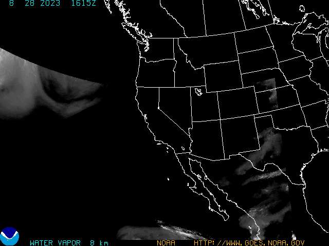
This is the water vapor map of the western U.S. There is an obvious "U" shaped line stretching across the Baja California Peninsula up through Colorado/Kansas. I believe this is called an upper-level trough.
Saturday, March 5, 2011
Saturday, March 5th
Current conditions are sunny skies with about 40 % cloud cover, mainly cirrus and cumulus clouds. It is 28 degrees F with 10 mph north/northeast winds. The rest of the day should remain the same, with a low of 9 degrees F tonight. Tomorrow I predict we will see similar temperatures and more north/northeast winds from the high pressure system to our north. There is a small chance for snow showers tomorrow night.
Thursday, March 3, 2011
Thursday, March 3rd
It didn't feel as warm as I had thought it would today, however there were a few snow showers this morning as I predicted yesterday. Currently it is still 30 degrees F at 7pm, which is impressive. There are light NE winds which will continue throughout the night. Due to the cloud cover it is going to stay relatively warm tonight, leading to warmer temperatures tomorrow. There is a warm front and a low pressure system to our south, and as they move east, we will have slightly warmer temperatures and east winds. The high will reach the mid 30s and there is another chance for precipitation.
Wednesday, March 2, 2011
Wednesday, March 2nd
I was correct in my prediction yesterday for a cold front moving across WI. It was especially noticable last night when the winds picked up and it got a lot colder. Currently it is 14 degrees F with a wind chill of 6 degrees F. Today there were clear skies due to the high pressure system being centered right over us. Now as the high pressure system has moved east, there is about 70% cloud cover with stratus and cumulus clouds, however it is hard to tell exactly because it is almost dark out. The winds have died down and are very light winds from the north. As the high pressure system continues to move east, it will give us south winds and warmer temperatures tomorrow. With the combination of a change in wind direction and a falling barometric pressure reading (according to http://metstation.uwec.edu/Current.htm), this indicates a chance for precipitation.
Tuesday, March 1, 2011
Tuesday, March 1st
As predicted yesterday, the high pressure system moved south and left us with warmer weather. The current temperature is 38 degrees F with about 45% cloud cover, mainly cirrus clouds. There are now two high pressure systems affecting the air movement in our area, one to our south and one to the southeast. This is accounting for our WSW winds. As a cold front passes over WI this evening and a high pressure system moves in from the north, we will see colder temperatures and a change in wind direction. The high for tomorrow will only be in the upper teens with light north/northwest winds.
 |
| Surface map from http://www.weather.com/maps/ at 2:22pm |
Subscribe to:
Posts (Atom)